I am sitting in my comfy chair enjoying the sun and doing my nails at the intersection of East Fork Road and US 26. The weather is beautiful. We started out, yesterday, from Meridian, Idaho, and are heading to Mount Rushmore Memorial in South Dakota. I drove straight through to Rupert, ID, where we gassed up the RV. We stopped at a rest stop and had lunch. Pete drove from there and I enjoyed the scenery and nodded off once, before we made it to Idaho Falls. We continued to Palisades Dam and on to Alpine, which is just across the border of Idaho and Wyoming. We stopped a couple times to stretch or legs and take some photos of the fabulous views.
 |
| Palisades Reservoir |
We stopped again just after Alpine and admired the river cutting down beneath the spikey rocked snow-covered peaks. We continued on toward Marrow, which took us through the Teton National Forest. I saw elk, deer, and we pulled over in a turnout, so I could get out with my tripod and take some photos of some buffalo across the road. There were eleven buffalo and one Canadian Goose. I had been to Yellowstone Park when I was about 14 years old, but we did not see buffalo at that time.
I think this is the first time I have seen buffalo in the wild. I used my tripod and the zoom on my camera to photograph the buffalo, so I could stay well away from them. I took over driving. We finally made our way down the smooth and scenic road to the Moran Junction. Then up, up to the top of the Great Divide. There was no one behind us, after we left Moran Junction, the entire way to DuBois. The road was clear, but the higher up we drove the more snow there was on either side. It was spectacular. We did meet a handful of vehicles coming from the other direction, but no one was there to pass us as we drove in the right-hand lane in the passing zones. The stone mountains were incredible looking. As we came down in elevation, we saw more deer and I saw some baby pronghorns. Just before getting into DuBois there seemed to be deer everywhere. I stopped once to let a deer cross the road and I drove cautiously into DuBois. I drove into the Sinclair station so we could gas up. I took a photo of the dirt road that ran next to the highway and was joking about it being “the Frontage Road.”
 |
| Frontage Road in DuBois, Wyo |
It turns out the KOA was also closed. But there were campers and RVs there. Pete got out and checked around to find someone but could not. It was 8 PM and still light out. We drove in and found a space to park in, nevertheless. We hooked up to the power and it worked. We were not concerned about water, so did not hook up. We had a pleasant evening. I cooked hot dogs and we had pork n beans, pickles, and salami with it. We watched the first two episodes of Murdock Mysteries, we had checked out from the library before our trip. Then lights out. I slept pretty well. Pete got up first while I laid under the warm covers for a little bit longer. He made his coffee. After we had breakfast Pete went to see if anyone had arrived to take our payment. I tidied up the RV. Turns out they don’t open until this Friday, but they were able to take our payment for the overnight stay; a flat rate of $20.00. Then we walked over to Wind River, which ran right past the campground.
It was a lovely place to stay. I drove us out and headed out to DuBois toward Riverton, which is 71 miles away. It is a lovely morning. Suddenly a loud rattling-banging noise occurred and I braked and determined it was a blow-out, looking quickly in both directions, I determined it was safe to cross the highway onto a flat spot on a dirt road on the left immediately ahead. I got us stopped, and was relieved to hear escaping air as I got out of the driver’s seat. With still-escaping air, I was hopeful not to have damaged any rims while crossing the cattle guard to our final resting spot. That is how I have come to do my nails here on East Fork Road near the highway.
Up this East Fork Road is gravel pit, apparently. One of the big trucks coming out of there, and heading toward DuBois, stopped and told Pete he would let the guy and the service station know we needed assistance. Meanwhile, I drug my chair out from the cargo bin and sat in the sun enjoying the leisureliness of the situation. I got my hand moisturized, nails filed and polished before the rescue truck arrived. This is some rescue truck. He had an air compressor to jack up the RV. He removed the outer tire. He said the blown tire had grabbed the exhaust pipe and wrapped it around the inner tire. Interesting situation. The inner tire was not damaged, but had lost it’s seal to the rim. Pete traveled back to DuBois with the rescue truck, to get the repair/replace business done. I stayed with the RV and typed this account on my laptop and enjoyed some cattle being herded past the RV and out onto the main road.
What a relaxing morning, for me, anyway. It only took about an hour and a half of our time. In the end, we had to purchase a new outer tire, mounting, and cost of cutting the exhaust pipe off.
We traveled on and waved to the returning cowboys and girl. They were returning after delivering their cattle to some pasture unknown to us. We had a scenic drive and we took a short-cut around Riverton. Pete was looking on our Atlas (circa 2013) and said it appeared that the last mile or so of the by-pass was an unpaved road. Luckily, that was not so in 2019. We tried to keep a steady pace, but stopped and had lunch at an extremely windy Rest Stop, where we never got out of the RV. After Casper we had interstate as far as just past Douglas. Then we headed toward Lusk.
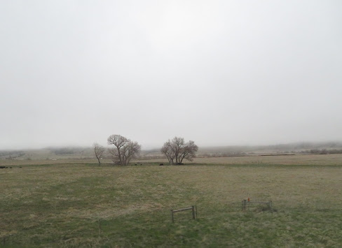
Oh, we ran into the thickest fog! Pete was driving. It was white knuckles for a while. The man at the Sinclair Station, in Lusk, said, “No water for a hundred miles all around and we have fog!” It got even thicker after Lusk, but we finally drove out of it. We swapped, and I drove from the Junction of 16, on into South Dakota. We stopped at the border and took photos at the border sign. I drove on toward Custer and, oh boy! more fog. I soldiered on into the looming whiteness, slowly. Then we were coming into Custer and I was doing about 40 and decelerating when suddenly a group of faces ran into the forward right quadrate of our view, like they were excited to say hello! One made it across the road in front as I braked and the others instantaneously dispersed. What no thud(s)? Wow, how surreal. Pete said he could see them out his passenger side window. He said they were in shock, because we did not stop for them to cross the road. It was six deer. Pete said he was happy it was me driving. Well, we made it to Custer, but the night was far from over.
Before we left home, I called and made a reservation at an RV park in Custer, SD. The day we left, we got a call from the RV reservation gal, Elisabeth, who said that RV park was not open yet, and she said Custer State Park was the only RV park open. She gave me their phone number, so I could call them and make a reservation. The next day, as we lunched at the extremely windy Rest Stop, we had a cell signal, so I called the number and reached the SD State Parks Reservation line, and got a reservation for Monday night for Grace Coolidge 2E at Custer State Park. Monday night drove into Custer in a little fog and the GPS was not giving us the correct location of Custer State Park. I saw a big sign directing us to the park, in the middle of town, but we never saw another sign. We started out of town on 16A looking for the address Michelle had given me over the phone. The fog got thicker and it was getting dark. The road was curvy and I could see about 20 feet ahead of the RV. I kept my eyes on the road between the yellow center line and the white line on the edge of the road. Pete had the GPS going and was telling me when a curve was coming to the right or left or if the road would be straight for a bit. We drove for 15 miles or more and did not find anything with the address on it or a sign for an RV park. We ended up at a resort where we took a brief break to determine what the hell was the deal!!? We reprogramed the GPS, double-checking the address and headed back the way we came. There was not anything but fog and darkness where this place was supposed to be. We did more determining and decided to pull out at the next wide spot and stop for the night. We did. We ran the generator for about 30 minutes, while making some hot tea and doing more determining. Strange we had wi-fi on the side of the road, but not up at the resort. The SD State Parks website sucks. There are no good maps of this state park and it’s relation to Custer. Finally, we came to a conclusion on Google maps that we likely passed it twice, but who the heck knows?! We turned off the generator and went to bed. I could not sleep, and my feet were freezing. I had on two shirts, my yoga pants, and my thick socks. At 2:45 a.m., I decide to put on my hoody and go to the bathroom. Pete was awake, too, so we turned on the generator and made more tea and warmed up for 35 minutes, then went back to bed. I put my jeans on over my yoga pants first. My feet were nice and toasty, so I was able to fall asleep for about two hours. At 5:30 I got up and we stowed a couple items and I pulled out on the road again, this time back into Custer. As we went down toward town, I saw two turkeys, then several deer and another turkey. We gassed up the RV at the Conoco and found out where there was a good local café that would be open for breakfast. I put my hoody on, so the hood was in the back and pocket in the front. We went to the Betty Boop Diner. We parked at the grocery store and walked about two businesses down. We got warmed up and Pete had some coffee and breakfast. I had tea and orange juice. What is with everyone charging a fee for using a credit card these days!? Four percent to use a credit card to pay for breakfast. I paid cash.
I drove back in the direction we had taken last night in the fog and darkness. We had never seen the sign saying we were entering the Custer State Park. We had not seen the “visitor center” or any other signs in the darkness and fog. We pulled into the “visitor center”, which was unmanned, and Pete picked up a couple brochures out of the kiosk. Oh, look the same lousy map as on-line. We found on there “Grace Coolidge Camp”. We headed in that direction, carefully taking note of every sign we could see along the way, in the daylight with no fog. Last night I had no idea what was on either side of the road. A lot to see this morning. Out of the trees, I drive, and there are four RVs parked in a camp area on the right. As we get closer, we see on the small wooden non-reflective sign, the words “Grace Coolidge”. Eureka!
I pulled in and Pete spotted. He got the power hooked up and we got the heat going. I fixed me a bowl of granola cereal, for breakfast. We closed the blinds and went back to bed. I woke up at ten a.m. feeling cozy and relaxed. It is always nice to wake up to rain pounding on the roof. We have hung out all day just relaxing. At one point I was doing the slug pose, while Pete did a walk-about with his camera. We have decided to go to Mt Rushmore tomorrow. I fixed tortilla pizza-tacos with mozzarella cheese, grilled tomatoes and onions for lunch. Yum. This afternoon we watched Mary Poppins Returns, then we made good use of the campground’s shower facilities. I washed and dried my hair and felt a whole lot better. It has rained all day.
Right now, Pete is rolling around in the crow’s nest cleaning and finding loose change. We are chilling out and relaxing. A dollar and thirty-six, he says. Tomorrow we are heading out to see Mt Rushmore, then heading toward the Devil’s Tower in Wyoming. We will dawdle our way back to Idaho.
We visited the Crazy Horse memorial site. It had an extensive museum that was quite interesting. In one area they had a wall of honor type display with all the important chiefs and braves represented. They had nothing on the wall about the women. I had seen, in our Rand McNally USA road atlas the site of Sacajawea's burial, so I asked Pete if we could stop there on the return trip to Idaho. Meanwhile, Indian women were at least fifty percent of the importance of the Native American races in my view.
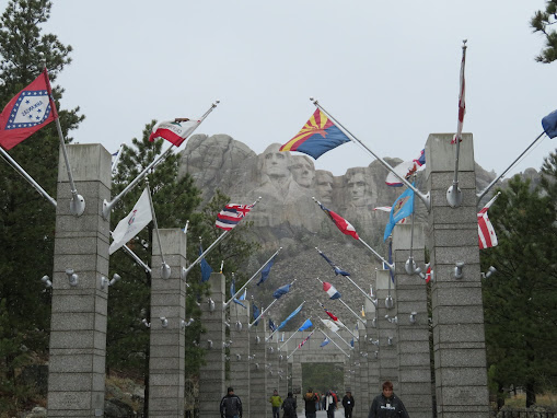
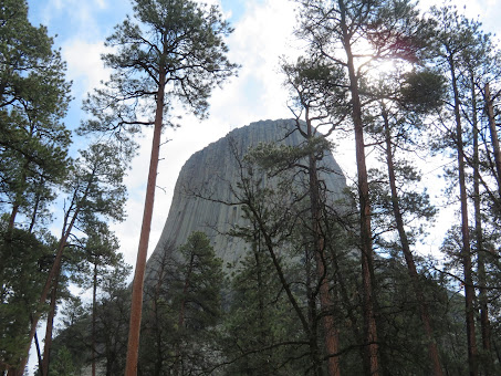
Both Crazy Horse and Mount Rushmore, had easy RV parking. That is important to us, since we are new to driving a 29 foot RV. We spent about an 45 minutes at Rushmore, where it was snowing, then we drove on northward, up the highway to Sunbird. It finally stopped snowing and we proceeded west to the Devil's Tower.When we got there, in the afternoon, the tower was fogged in. The shot above was the best I could get. We left and went to an RV park, where we had an excellent view of the Devil's Tower. We ate our dinner and watched the fog lift from our RV window.
Pete bought an annual National Parks pass, the afternoon we arrived, so we went back the next day, when the sky was clear and had a really enjoyable time hiking around the Devil's Tower.
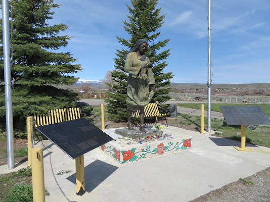
After our fun at The Devil's Tower, we headed out and, by the next day, reached Fort Washakie. It is on a huge Indian Reservation. We found a sign pointing to where Sacajawea's grave is, on Highway N287 in Wyoming, but after that no further indications. We looked around at one cemetery, that had a memorial to Washakie, the great Shoshone Chief, but could find no sign of Sacajawea. We proceeded along to a fork in the road, where we went left for half a mile, then came back and went right for half a mile. Then went back toward the other cemetery. That is where we met George, who was very helpful and friendly. He drove ahead of us and lead us the Sacajawea Cemetery, which was about 1.5 miles up the left fork of the road. George pointed out his brother's house and said, he might ought to pay him a visit, since he had not seen him in a while. The cemetery was amazing. I was so glad we sought it out.
Then, we traveled on to Du Bois and back into Idaho. It was a wonderful trip. I found The Devil's Tower to be the most impressive sight on our RV adventure. Our main destination was Mt Rushmore, however, it was the least impressive of all the sights we saw on our trip, which just confirms that traveling is about the journey, not the destination.


No comments:
Post a Comment